At Sugatami, 1,600 metres up the side of Asahidake, the ropeway doors open onto thin cold air and the smell of sulphur. Across a small pond the mountain stands whole, its upper slopes streaked with old snow, and from a crater on the face turned towards the water the fumaroles send up white columns of steam that hiss loud enough to be heard from the shore. On a still day the pond holds the mountain upside down, which is how it got its name: sugatami, the mirror.
This is where the Asahidake to Kurodake traverse begins, the pinnacle of hiking in Hokkaidō. It runs about 13 kilometres from the top of the Asahidake ropeway, over the summit of Asahidake at 2,291 metres, the highest point on the island, along the rim of the Ohachidaira caldera past Mamiyadake and Hokkaidake, and over Kurodake to the ropeway that drops to the onsen village of Sōunkyō. A fit walker needs seven to eight hours and a little over 1,000 metres of climbing in all, most of it in the first two hours.
The mountains it crosses are Daisetsuzan, designated a national park in December 1934. At 226,764 hectares it is the largest national park in Japan, larger than the whole of Tokyo Metropolis, and its high ground is a rolling plateau of rock, snow and alpine meadow above the treeline. The Ainu call it Kamuimintara, the playground of the gods. Up on the plateau the name stops sounding like poetry. The ground steams, the snow lies beside the flowers, and the Japanese pika, a small round-eared cousin of the rabbit that has lived in these boulder fields since the last ice age, whistles from the rocks.
the route
The Asahidake to Kurodake traverse, ropeway to ropeway
The day starts at Asahidake Onsen, on the mountain's western foot at 1,100 metres, where the ropeway lifts walkers 500 metres in about ten minutes to Sugatami station. A path of 1.7 kilometres loops round the pond and beneath the fumaroles, and it is the walk most visitors take, an hour among the first of the flowers. The traverse leaves it on the far side of the pond and turns straight uphill.
The climb to the summit is the hardest part of the day, close to two hours and some 690 metres of loose volcanic grit, with the steam vents below the path for much of the way and their sulphur on the wind. From the summit, on a clear day, the whole range lies open: the Tokachi peaks to the south, the plateau rolling east towards Kurodake, and on the far side a long slope of old snow that holds on into August.
Beyond it the route drops to a saddle and climbs again to Mamiyadake, 2,185 metres and about an hour on, where it reaches the rim of Ohachidaira. The caldera opens below, a great bowl of grey and ochre ground whose floor is closed to walkers and left to itself. Two paths ring it. The northern takes in Hokuchindake at 2,244 metres; the southern, a little shorter, passes Hokkaidake at 2,149 metres and crosses a stream of snowmelt. Both arrive at the stone hut below Kurodake.
Twenty minutes above the hut stands Kurodake, 1,984 metres, the last summit of the day. From it the path drops steeply for about fifty minutes to the seventh station at 1,520 metres, and a chairlift of fifteen minutes and a ropeway of seven finish the descent through birch and fir to Sōunkyō at 670 metres, where the Ishikari River runs through a gorge of columnar cliffs.
Two ropeways, four summits, and a hot spring at the end of it.
the mountain's year
Alpine flowers and Japan's earliest autumn colour
Summer on Daisetsuzan comes late and moves fast. The snow leaves the high ground slope by slope, and each patch of meadow flowers as soon as it is uncovered, so that one hollow is white with bloom while the next is still white with snow. Chinguruma, the Aleutian avens, is the plant of these mountains: a dwarf shrub barely ankle-high whose five-petalled white flowers cover whole hillsides around Sugatami and the plateau of Susoaidaira in July, then turn to plumes of silver seed by August. In the wet ground below the snowfields grows ezo-kozakura, a primrose of deep pink no taller than a hand, and between the rocks the pale yellow of kibana-shakunage, the alpine rhododendron. The meadows of the traverse are in flower through July and August, as the snow gives them up.

The same plants make Daisetsuzan's autumn, which is the earliest in Japan. From the middle of September the chinguruma turns crimson at the walker's feet, nanakamado, the Japanese rowan, goes orange and scarlet across the slopes, and the dwarf birch turns gold, while the temple gardens of Kyoto are still green. The first snow follows in October, and the colour on the high ground is over before most of the country has begun.

Through every season the ground breathes. Asahidake is a volcano still warm at its core, and the fumaroles above Sugatami and the hot springs at both ends of the traverse are the same heat finding its way up. To walk with old snow on one side of the path and warm, yellow-crusted rock on the other is the particular strangeness of this range, and the reason the Ainu name sits so easily on it.
the bear
Brown bears in Daisetsuzan
The Hokkaidō brown bear, the higuma, lives throughout the park, and to see one is among the great moments a day in these mountains can give: a dark shape crossing a snowfield far below, or turning over stones in a meadow on the opposite slope, wholly absorbed in its own day. Walkers in the Hokkaidō hills carry a small bell on the pack, so that a bear ahead hears a person coming and moves off before the two meet. The courtesy runs both ways. Walkers keep to the path, leave the animal the whole width of the valley, and watch.
the day
A day on the traverse with a Tour Director
Done privately, the traverse turns on arrangement more than on legs. The two ropeways stand on opposite sides of the range, a long drive apart by road, so the day begins with a private car to the foot of the Asahidake ropeway and ends with the same car, sent round the mountains while the guests walk, waiting at the foot of the Kurodake ropeway in Sōunkyō. A Tour Director walks the day beside them, sets the pace to theirs, and times the descent so the chairlift from Kurodake is met without a moment's hurry.
Lunch is carried up and eaten on the rim of Ohachidaira, the caldera open below and the plateau running away on every side.

At the bottom waits Sōunkyō, the largest hot-spring area in central Hokkaidō, and the onsen. Sitting in mineral water at the end of a day on the high ground, with the cliffs of the gorge standing straight up beyond the glass, every one of the thirteen kilometres leaves the legs at once. Few days anywhere in Japan end better.
Daisetsuzan does not demand the whole traverse. The loop around Sugatami passes the fumaroles, the pond and the first of the flowers in about an hour. The Kurodake ropeway and chairlift lift a guest to 1,520 metres without a step of climbing, onto slopes where the alpine plants grow right up to the station. The summit of Asahidake alone, up from Sugatami and back, makes a long half day.
further afield
Other walks in Hokkaido
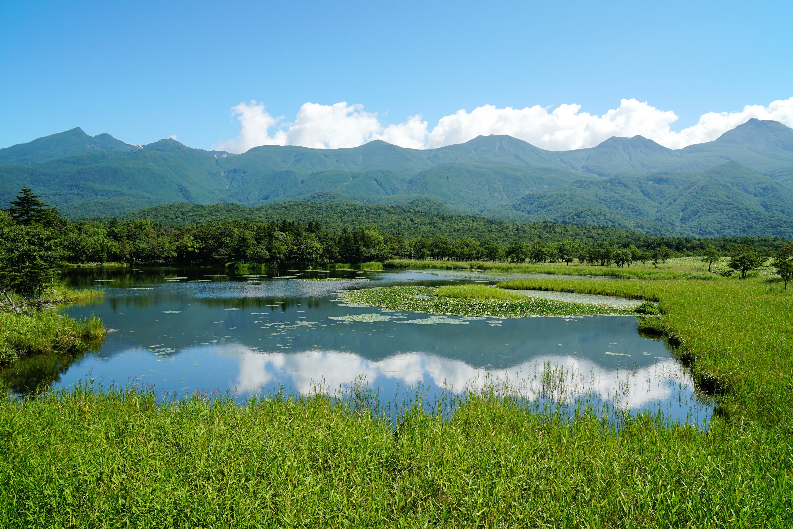
Shiretoko, inscribed as a World Heritage Site in 2005 on the far north-east of the island, has the gentlest of the great Hokkaidō walks. At Shiretoko Goko, the Five Lakes, a raised wooden boardwalk runs about 800 metres over the bamboo grass to the first lake, level the whole way, with the peaks of the Shiretoko range standing in the water and the Sea of Okhotsk behind. A ground path carries on through old forest to all five lakes, entered after a short briefing from the park staff at the trailhead.
Lake Mashū, in Akan Mashū National Park, cannot be walked to at all. Its shore is closed, and the lake is known only from above, so the walk worth making is the trail along the caldera rim to the summit of Mashūdake, 857 metres, with water of an almost black blue below for the whole of the way.
On the far side of Shiretoko from the Five Lakes, the Rausu coast faces the Nemuro Strait. A road follows the shore north from Rausu to Aidomari, about 20 kilometres short of the cape, and in summer the stony beaches along it are laid with drying Rausu kombu, a kelp that grows only in these waters and spends two years in the strait before it is cut. Past Aidomari the road ends, and the coast goes on by foot and by sea.
the journey
A journey from these pages
The Wild North Tour of Hokkaido opens in Daisetsuzan. Its first night is spent at Sōunkyō, in the gorge at the foot of Kurodake, and the Kurodake ropeway lifts guests above the cliffs into the alpine high country at 1,300 metres, where the ground is threaded with steam. From there the journey turns east, to three nights on the Shiretoko coast, a boat beneath the World Heritage cliffs where brown bears walk the tideline, and the blue-black of Lake Mashū from its rim. It runs from 27 July to 6 August 2027.
The Summer Tour of Hokkaido, opening at Shirogane beneath the Tokachi peaks of Daisetsuzan →
questions
Questions
How hard is the Asahidake to Kurodake traverse?
It is a full day for a fit walker: about 13 kilometres, a little over 1,000 metres of climbing and seven to eight hours, with loose volcanic ground on the climb to Asahidake and a steep, rocky descent from Kurodake. No climbing skill is needed; good boots and walking poles matter more than anything else.
When do the Asahidake and Kurodake ropeways run?
Both ropeways run through the year, with pauses for maintenance. The Asahidake ropeway climbs from 1,100 to 1,600 metres in about ten minutes; the Kurodake ropeway climbs from Sōunkyō to 1,300 metres in seven, with a chairlift on to 1,520 metres. The high trail is walked once the snow has left it, and the first snow returns in October.
Do I need a guide to hike in Daisetsuzan?
No guide is required for the traverse, which is a marked trail walked by many each summer. What it asks for is arrangement: the two ropeways stand on opposite sides of the range, so a car has to be waiting at Sōunkyō, and the last chairlift down from Kurodake sets the end of the day.
Are there bears in Daisetsuzan?
Yes. The Hokkaidō brown bear lives throughout the park. Walkers carry a small bell so that a bear hears them coming and moves off, keep to the trail, and watch any bear they see from a long distance.
What should I wear to hike Asahidake?
Layers. Sugatami, at 1,600 metres, is cold even in high summer, and the summit is colder and windier still, so a waterproof jacket, a warm layer, a hat and gloves go in the pack with water and lunch. Boots with a firm grip suit the volcanic grit of the climb, and walking poles help on the descent from Kurodake.